Exploration & Mining
Explore our wide range of innovative products designed to meet the unique needs of various disciplines, industries, and applications. From cutting-edge technology solutions to specialized equipment, Datacode Geosciences is your trusted partner in delivering reliable and efficient tools that empower your operations.
Exploration & Mining
With flexibility to only use what you need, when you need it – combine one or more of our products for a tailored solution.
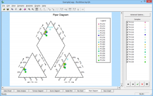
AqQA
Software for water analyses: unit conversion, ion balance, sample mixing, basic fluid properties calculations, water chemistry diagrams (Piper, Stiff), and more
Learn More

Target
Automate routine data processing tasks and streamline workflows to spend less time processing data and more time exploring.
Learn More

Target for ArcGIS
View drillhole data attributes in 2D maps and 3D scenes. Create cross sections to view and interpret your geology in 3D.
Learn More

ModelVision
ModelVision provides geophysical modeling and inversion tools for interpreting gravity and magnetic data, ideal for mineral exploration projects.
Learn More

Oasis Montaj
Oasis Montaj offers powerful data processing capabilities for geophysical and geological datasets, perfect for large-scale exploration projects.
Learn More

Global Mapper
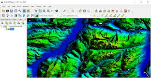
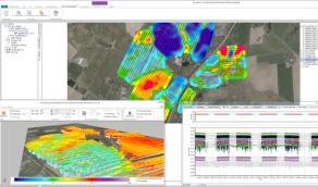
Global Mapper supports a wide variety of spatial data formats, offering essential tools for terrain analysis, GIS mapping, and geospatial data management.
Learn More

LogPlot
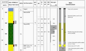
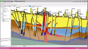
LogPlot makes borehole data visualization easy, allowing users to create detailed well logs with customizable templates for various geoscience applications.
Learn More

Maxwell (EMIT)
Maxwell (EMIT) provides advanced electromagnetic data modeling tools, helping geoscientists visualize subsurface structures with precision.
Learn More

RES2DINV (GEOTOMO)
RES2DINV offers precise tools for 2D resistivity and induced polarization (IP) inversion, perfect for environmental and geotechnical applications.
Learn More

RES3DINV (GEOTOMO)
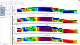
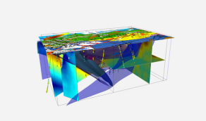
RES3DINV offers advanced 3D subsurface imaging, providing accurate resistivity and IP inversion for complex geophysical projects.
from geological survey to advanced geotechnical design.
Learn More

Rockworks
Rockworks provides versatile tools for 2D and 3D geological modeling, making it an essential solution for subsurface exploration and analysis.
Learn More

Surfer
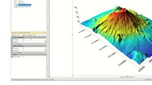
Surfer offers advanced tools for gridding, contouring, and 3D surface mapping, providing geospatial professionals with precise data visualization options.
Learn More

WellCAD
WellCAD is a complete well log software, offering tools for processing, analyzing, and visualizing borehole data in geoscientific applications.
Learn More

Imago
Imago provides powerful tools for managing high-resolution drill core images, enabling geologists to extract valuable insights from visual data.
Learn More

GOCAD Mining Suite
GOCAD Mining Suite provides comprehensive tools for 3D geological modeling and geostatistical analysis, tailored specifically for the mining industry.
Learn More